SOLO BIKE RIDE TO WAYATINAH, CENTRAL HIGHLANDS©
TONY WATTON
26/10/2012 to 28/10/2012
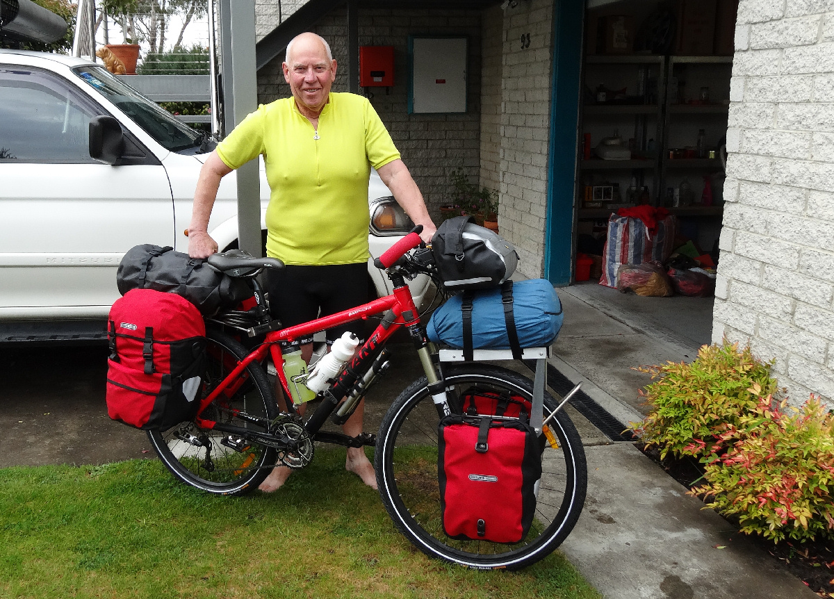
Bike packed and (nearly) ready to go
This solo bike trip started out as a clockwise ride around Tasmania, from Lauderdale. About 10 years ago I had made two trips, each of half of the State ( Solo Bike Tour of Eastern Tasmania and Solo Bike Tour of Western Tasmania ) and ever since then I have had a plan to combine the two for a complete circuit.
The time arrived this month, when I considered that I would be able to do the trip in about four weeks, depending on any side trips I might make - for example out to Ocean Beach west of Strahan and to Cape Grim in the far north-west.
I had my bike (Giant XTC 2) set up with Tubus pannier racks and Ortlieb panniers, plus a home-made front rack for my sleeping bag. All was set for a departure on Friday 26/10/12.
Day 1 - Friday 26/10/12 - Lauderdale to New Norfolk (51kms, 6hrs 30mins)
Matthew and I weighed the individual packs just before I left on the first stage of what I hoped would be a complete lap around Tasmania.
Weights recorded were:
Tony
87.2kgs
Bike
19.2kgs
Front right pannier
3.9kgs
Front left pannier
3.9kgs
Rear right pannier
9.1kgs
Rear left pannier
9.1kgs
Tent, poles, pegs, tarp
4.3kgs
Sleeping bag
1.8kgs
Handlebar pack
2.2kgs
Total weight of gear carried was 34.3kgs. I must admit I was a bit apprehensive about how heavy all this gear was, but as I expected to be on the road for up to four weeks, this was what I thought I would need (assuming most food would be bought at towns passed through - except the Western Explorer Road).
At 9.00am I was ready to go. A nice touch was that some of our neighbours came out to wish me the best of luck. I thought I needed it!
The route I chose to get to the western shore was one where I wanted to avoid as many steep sections as possible, being the first day - so I chose to travel through Rokeby, Howrah, Bellerive and Rosny before reaching the Tasman Bridge. My first encounter with walking the bike came as early as Rokeby hill. At the bridge it was clear that I would need to push the bike up the narrow path because the wind was so gusty. In fact I had to walk the bike down the other side of the bridge as well. Apart from the wind, I had discovered that the weight of the gear on the front wheel made the bike less responsive than an unloaded bike would have been at low speeds and course corrections took longer to achieve. Because of this I could not keep the bike in a straight line on the narrow bridge footpath whilst riding.
After the bridge I stayed on the Intercity Bike Track before joining the Brooker Highway for the continuation of the ride to Granton.
I arrived at Granton just after 1.00pm and spent a pleasant 30mins or so enjoying a cup of coffee and a snack bar.
Immediately I joined the Lyell Highway to New Norfolk the rain started - gentle at first - but then a full-on downpour that lasted for a distance of about 8kms (of the total 16kms to New Norfolk). Added to this discomfort I was riding into a strong westerly headwind. The annoying thing about this was that, even on downhill sections of road, I could only manage between 10kms/hr and 12kms/hr in a very low gear.
It was a great relief to arrive, at 3.30pm, at the New Norfolk Caravan Park (total distance 51kms). Even though I carried all my gear I couldn't resist the temptation to hire a cabin (shower, heater, comfy lounge, bed, tea, coffee etc, etc). After changing my clothes and unpacking I walked along to the town centre to buy a few items for an evening meal. I spend a very pleasant evening, drying clothes and relaxing on the couch.
Another interesting day tomorrow!
Day 2 - Saturday 27/10/12 - New Norfolk to Hamilton (38kms, 6hrs 30mins)
Even though I was up at 6.00am, I seemed to take for ever to actually get things done. Consequently, by the time I was ready to leave it was close to 9.15am. Still, a very pleasant and comfortable night.
The riding this day was a lot easier than what I had encountered on Friday. As I was heading in a generally north-westerly direction the wind must have been mostly from the south as it was coming over my left shoulder a lot of the time. I even had short periods of tail winds. Joy.
However, the hills were another kettle of fish altogether. I had to walk the bike up a few of the steeper sections. The only consolation for me is that, whereas I can push the bike uphill at maybe 4kms/hr, in the lowest gear (of 27) I can only manage 5kms/hr, at best. I was beginning to think, in view of these past two days of travelling, that I needed to reassess my daily expected distances, especially all the way to Marrawah.
I spent an interesting 45mins or so with a group of Harley riders, who were on a charity ride for children's cancer, at the Gretna Green pub.
On Sunday I would like to make it to Tarraleah. However, a more realistic target might be Wayatinah (39kms as against 53kms).
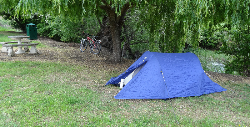
At about 3.30pm I arrived at the Hamilton camping ground and found a very nice campsite near the Clyde River, close to a picnic table. Hot showers ($1) and toilets just up the hill. There were quite a few campervans and caravans but no noisy neighbours to disturb the peace.
Later I spent a very pleasant couple of hours at the old Hamilton pub, reading about the history of the area and enjoying a welcome counter tea.
Day 3 - Sunday 28/10/12 - Hamilton to Wayatinah (45kms, 8hrs 30mins)
I had a very good night's sleep, from about 8.00pm to just before 5.30am, when my watch alarm sounded.
Breakfast consisted of a rock cake (purchased at New Norfolk two days earlier) and water. I thought I might get a more substantial breakfast at Ouse, 19kms away so I wasn't too concerned about my poor breakfast.
Once again, I seemed to take an inordinately long time to get my gear packed away, so it was 9.00am by the time I left Hamilton. As expected, the road undulated, twisted and turned but was generally in an uphill direction. I pushed the bike up a few of the more challenging hills and, as I did so, I again wondered how I would cope with longer, steeper climbs on the way to the West Coast.
At Ouse my common sense apparently deserted me because, rather than buying a toasted sandwich as well as a hot drink, all I got was a cup of coffee at the service station. I still can't explain my stupidity.
I pushed the bike up quite a few hills on the way to Wayatinah and enjoyed a fast (65kms/hr) downhill run on the way.
As I approached Wayatinah I remembered Matthew's text message that the shop at the village was open only from 9.00am to 11.00am on a Sunday but I had forgotten that the tavern only opened from 4.30pm. (I also omitted to check the sign at the highway turn-off.)
So, just before 3.00pm I detoured the 3kms or 4kms to the Wayatinah village, expecting to get a cold drink and something to eat at the tavern. Needless to say, it was closed, so I contented myself with some water. Not seeing a handy tap, I was unable to replenish my water supply.
I made several mistakes on this leg of my trip:
1. I did not put snacks in the handlebar bag that I could munch on during the day. The food bag was at the bottom of a pannier.
2. I took insufficient water, having 1 litre in my Camelbak and 1.5 litres in water bottles when I started the day at Hamilton.
3.
My running shoes were packed well down in one of the panniers and I didn't know
which one of the four they were in. I should have
simply found them, as walking the bike with bike shoes and
cleats is less than
an ideal way to travel.
Just after 3.00pm I decided that, with only 14kms to go to Tarraleah I would at least get up to the plateau for a well-earned rest for the night. I knew I would need to push the bike 10kms up the hill to the canal before the road levelled out before taking the side road to Tarraleah village. Almost immediately, I discovered that it was going to be a very long, hard slog.
With my Garmin Edge 800 on the bike, and my heart rate monitor, I was able to continuously check my heart rate and so was very much aware of my (lack of) progress.
It may be only an approximate guide but, if a person's maximum heart rate should not exceed 220 beats/min (bpm) minus the rider's age, then my maximum heart rate was to be 152 bpm. I know I had previously exceeded this for short periods of time (up to 167bpm on Day 1) but not for a long stretch like the Tarraleah hill. In addition, if I were to maintain not more than 85% of that maximum, then my exercise level was to be around 129bpm.
As I plodded up the hill in my bike shoes, walking just off the road in gravel, rocks, branches and other rubbish my heart rate rose rapidly to 140bpm. Not sustainable.
In order to put some discipline into my walking, I decided to walk 2 or 3 guide post distances, by which time my heart rate rose to 139bpm then rest until it dropped back to 120bpm before my next move. Meanwhile, my meagre water supply was almost exhausted.
I continued up the hill until I reached an open area of Forestry operations off to the left side of the road. At this stage I had plodded 3kms up the hill in just over 2hrs. Time was about 5.15pm.
I quickly worked out, in my head that, at this slow pace and not allowing for future tiredness, the remaining 7kms to the canal might take me between 4hrs and 5hrs. That is, I could not expect to finish pushing the bike until 9.00pm at the earliest - more likely 10.00pm. It was clearly not going to happen. The prospect of pushing my bike up the hill in the dark with only my flashing back light for "protection" was not all that appealing to me.
Amongst many other thoughts, I couldn't get out of my head what James Castrission (of Cas & Jonesy) had written in his book "Extreme South" for me - "Never Give Up". Fine sentiments indeed.
But the reality of my situation now struck me. I had bitten off more than I could chew and I decided there and then that I could no longer continue my ride around the State.
I tried to call Matthew on my mobile so that I could let him know I would be heading back downhill to the Wayatinah camping ground. He had previously said he would catch up with me on the road on Monday 29/10 as he had a couple of days off. No signal. However, when I had stopped at the village earlier I noticed a pay phone near the shop. The run back down the hill took just over 3mins!!
I set up the tent in a pleasant grassy area and locked up the bike to a nearby tree, changed into casual clothes and wandered up the side road to phone Matthew.
He wasn't surprised that I was at Wayatinah but he was surprised when I told him that I had abandoned the ride. Being a great son, he immediately offered to drive up to collect me, if I felt that this really was the end of the ride. I did and it was. To fill in the time while he drove from Midway Point I had a couple of beers and a hot chicken roll at the tavern - the first real food all day. I watched some of the Ryobi Cup match between Victoria and Tasmania. (Victoria eventually won by 25 runs.)
I then headed back to the camping ground, packed up my gear and waited the remaining 30mins or so until Matthew arrived. There was a bit of a post mortem with Matthew, including some alternative possible rides etc. Then a pleasant drive back home to Lauderdale.
THANKS MATTHEW. I APPRECIATED YOUR KINDNESS.
Back home, from the comfort of my lounge chair, I wonder why I did not seriously consider the following options:
1. Ensuring I had enough water for the hill climb to Tarraleah while I was at Wayatinah.
2. Waiting for at least a day at Wayatinah and then attempting the hill when I had recovered from the ordeal.
3. Camping off to the side of the road where I stopped on Sunday and then continuing with the climb when I felt better.
4. Changing my bike shoes for more practical running shoes.
5. Getting food out of the pannier to ensure I had enough to eat while walking up the hill.
Perhaps my run-down physical condition affected my judgment to a greater extent than I had realised.
In retrospect, I still think it would be possible for me to do this ride, but it would probably need to start by heading up the East Coast, that is in an anti-clockwise direction rather than clockwise.
Medical Issues
As with other recent trips (walking and cycling) I have had to deal with having a suprapubic catheter following radiation therapy for prostate cancer. In order to avoid possible infection problems, such as might be caused by not being able to shower regularly while on a walk or ride, I ensure that the entry site of the catheter is thoroughly cleaned with alcohol swabs each day and covered with a non-stick dressing.
On this particular ride, as on the ride with Matthew to Cockle Creek ( Ride to Cockle Creek ) I experienced dark red blood in my urine. This was probably caused by the end of the catheter irritating the inside surface of my bladder. Whereas on the Cockle Creek ride the problem disappeared after two days, on this ride it lasted through the third day as well. The urologist had previously not seemed to be overly concerned about this, so I don't worry about it too much.
Other than the inconvenience of having the catheter in place I think I cope fairly well and it has generally not prevented me from doing whatever I want to do.